


montours parc floral 21km

coglais
Gebruiker
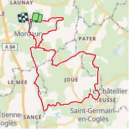

Lengte
21 km

Max. hoogte
175 m

Positief hoogteverschil
273 m
Km-Effort
24 km

Min. hoogte
113 m

Negatief hoogteverschil
272 m
Boucle
Ja
Datum van aanmaak :
2019-06-05 10:09:18.533
Laatste wijziging :
2019-06-10 10:39:29.118
4h00
Moeilijkheid : Medium

Gratisgps-wandelapplicatie
 SityTrail
IGN / Geografische instituten
SityTrail Plus
De wereld gaat voor u open
Over ons
Tocht Noords wandelen van 21 km beschikbaar op Bretagne, Ille-et-Vilaine, Les Portes du Coglais. Deze tocht wordt voorgesteld door coglais.
Plaatsbepaling
Land:
France
Regio :
Bretagne
Departement/Provincie :
Ille-et-Vilaine
Gemeente :
Les Portes du Coglais
Locatie:
Montours
Vertrek:(Dec)
Vertrek:(UTM)
625195 ; 5367038 (30U) N.
Opmerkingen